🗺️ Your Ultimate Guide to the UK – Map Your Journey!
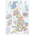
The UK Wall Map is a large, laminated map that provides detailed insights into County, District, and Unitary Authority boundaries across the United Kingdom. With a size of 120 x 83 cm, it features a roadmap of motorways and primary roads, along with population figures for towns and cities. The map includes a smaller inset for postcode boundaries and London Boroughs, ensuring you have all the essential information at your fingertips. Durable and easy to use, this map is perfect for both planning and educational purposes.
| Manufacturer | Map Marketing |
| Brand | Map Marketing |
| Product Dimensions | 83 x 0.2 x 120 cm; 390 g |
| Colour | Laminated |
| Size | 120cm X 83cm |
| Paper Finish | Satin |
| Manufacturer Part Number | BIC-18 |
| Item Weight | 390 g |
Trustpilot
2 months ago
1 week ago